
Hisar is the administrative headquarters of Hisar district of Hisar division in the state of Haryana in northwestern India. The city lies on National Highway 9 and National Highway 52. National Highway 9 from Pithoragarh to Malout connects it to Rohtak and Sirsa and National Highway 52 from Sangrur to Ankola connects it to Narwana and Jaipur and connected to Kaithal. The state highways of Haryana that pass through Hisar are State Highways 10, 13, and 20. Hisar is a railway junction station, and it falls under Bikaner division of Northwestern Railway Zone. The city has a large steel industry and is known as the 'City of Steel'. As of June 2012, Hisar is India's largest manufacturer of galvanized iron.
Awarded as the India's Most Promising Drone Consultants,IG DRONES is now the leading drone service providersin India. IG Drones was founded in 2018 with the goal of providing enterprise drone solutions across India andrevolutionising traditional industrial procedures with highly efficient drones. It is one of Hisar's top drone service providers. In the North Indian states of Jammu, Haryana, Punjab, Rajasthan, Uttarakhand, Himachal Pradesh, Uttar Pradesh, and Chandigarh, IG Drones uses drones to deliver drone survey solutions, drone mapping, and inspection services in Hisar and the surrounding areas.


IG Drones is India’s leading Drone Service provider company providing highly accurate & detailed GIS Survey, Topographic survey, Drone Inspection, Drone Mapping, Powerline Monitoring, Smart City Survey, Road Inspection & Survey, Mines Survey, Flood Assessment, Asset Monitoring, Solar Thermal Inspection, Security and Surveillance, Crop Health Monitoring, Volumetric Measurement, Drone 3D Mapping & Modelling, Aerial Photography & Videography and many more using advanced drone technology and providing meaningful data for businesses using the latest drone technology. Since 2018, IG Drones has been delivering high-quality drone survey and mapping services in Hisar and other regions in the states of Lucknow (Uttar Pradesh), Chandigarh (Haryana), Chandigarh (Punjab), Jaipur (Rajasthan), Dehradun (Uttarakhand), Srinagar (Jammu).
Get in touch with IG DRONES to experience the India's best Drone Service Company first-hand
Contact Us!We have clients across Punjab & other Northern states like – Department of Atomic Energy (DAE), Indian Railways, Northern Railways, National Disaster Management Authority(NDMA), National Highway Authority of India (NHAI), PowerGrid, Delhi Integrated Multi-Modal Transit System (DIMTS) Ltd., NRRI, Delhi Development Authority(DDA), Delhi Transco Limited (DTL), Adani, The World Bank, Reliance Power, Adani Transmission, Sekura, Indigrid, Transrail, Aditya Birla Hindalco, Aditya Birla Renewables, Navayuga Group, Indian Oil Corporation, HCL Foundation, Jakson Group, IL&FS, Humanitarian Aid International(HAI) etc.


.png)
.png)
.png)


At IG DRONES, we are always working on something new! We are proud of our latest work.
Some of our notable drone services across the industries include
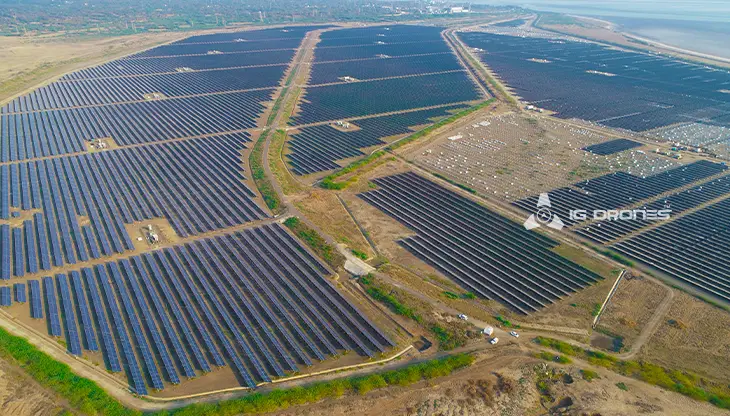
IG DRONES uses breakthrough drone technology to offer an adaptive and scalable end-to-end solution. Our aerial survey, mapping, and inspection services have aided the government and corporate sectors of the country in preserving assets to their full potential. Drone-based Powerline Monitoring, Industrial Inspection, Bridge Inspection, Solar Plant Inspection, Pipeline Inspection, Railway Services (Survey, Mapping & Inspection), Smart City Survey, Road Inspection, Mine Survey, Agricultural Survey, Forest & Wildlife Survey, Disaster Assessment, Wind Turbine Blades Inspection, Port Survey, Buildings & Skyscrapers Inspection, and Monuments Inspection are just a few of the services we provide.
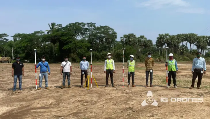
The objective of IG Drones is to provide airborne drone surveying, mapping, and inspection services to clients throughout the world. We excel in a variety of industries, including land surveying, aerial surveys for land management and development, land slope monitoring, stockpile volumetric measurements, smart city design, greenfield project mapping, and others. IG Drones places a premium on accuracy, and as a result, offers highly precise topographic maps with centimetre-level precision on a regular basis. Drone Data Processing is the latest geospatial technology trend, with drone applications spanning a wide range of sectors. Thanks to high-end surveying drones and a team of skilled licenced pilots, our clients get their deliverables sooner. Using Artificial Intelligence and Machine Learning, we continue to achieve up to 99 percent accuracy in Volumetric Measurements, Crop Yield Estimates, Damage Detection, and other areas. This pushes people to make decisions more quickly.


Talk to our team if you have any questions about drone surveying for your industry.
Contact Us for Drone Services in Haryana Contact UsIG Drones provide specialist drone services at height and difficult to access areas across India. Technical end-to-end solution to help you ease your operation. Capture the smallest of details with ease. Raise your operational standards & Imagine more with us. Imagine Inspire Innovate.
