
Dibrugarh is a city in Upper Assam with sprawling tea gardens. It serves as the headquarters of Dibrugarh district in the state of Assam in India. Dibrugarh is considered as an economic hub of North East region of India.Today, Duliajan, Dikom, Tengakhat and Moran are the key locations for oil and gas industry in the district. Oil India Limited, the second public sector company in India engaged in exploration and transportation of crude oil has its field headquarters in Duliajan. The Duliajan-Numaligarh pipeline will be the first major cross-country natural gas pipeline in Assam and once the availability of natural gas is ensured, it is expected to be extended to major consumption centers of natural gas in Nagaon and Guwahati.Dibrugarh Town and Dibrugarh are two railway stations of the city and also two of the important Easternmost railway stations on the map of the Indian Railways. Dibrugarh also possesses a developed waterway transportation system along and across the Brahmaputra River, known as the National Waterway 2 which extends from Bangladesh Border to Sadiya. Ferry services link Dibrugarh with Sengajan (Dhemaji District), Panbari ( Dhemaji) & Oiram Ghat (near Jonai Dhemaji).
In 2018, IG Drones was established with an aim to provide enterprise drone solutions PAN India and revolutionise the conventional industrial methods using highly efficient drones. It is one of the most well-known& leading drone service providers in Dibrugarh, Assam.IG Drones uses drones to deliver drone survey solutions, drone mapping, and inspection services inDibrugarh& the surrounding areas in the states of Arunachal Pradesh, Manipur, Meghalaya, Mizoram, Nagaland, Tripura & Sikkim.


IG Drones is India’s leading Drone solutions company providing highly accurate & detailed GIS Survey, Topographic survey, Drone Inspection, Drone Mapping, Powerline Monitoring, Smart City Survey, Road Inspection & Survey, Mines Survey, Flood Assessment, Asset Monitoring, Solar Thermal Inspection, Security and Surveillance, Crop Health Monitoring, Volumetric Measurement, Drone 3D Mapping & Modelling, Aerial Photography & Videography and many moreusing advanced drone technology and providing meaningful data for businesses using the latest drone technology.Since 2018, IG Drones has been delivering high-quality drone survey and mapping services in Dibrugarh& Guwahati (Assam) and other regions of Itanagar(Arunachal Pradesh), Kohima(Nagaland), Imphal(Manipur), Shillong(Meghalaya), Agartala(Tripura), Aizawal(Mizoram).
Get in touch with IG DRONES to experience the India's best Drone Service Company first-hand
Contact Us!We have clients across Assam & other North-Eastern states like – Department of Atomic Energy (DAE), Indian Railways, North Eastern Railway,National Highway Authority of India(NHAI), PowerGrid, Coal India, NRRI, Sekura Energy Limited, Sekura Roads Limited, The World Bank, Reliance Power, Adani, Sekura, Indigrid, Transrail, Aditya Birla Hindalco, Aditya Birla Renewables, Navayuga Group, Indian Oil, HCL Foundation, Jakson Group, IL&FS, MCL, Humanitarian Aid International(HAI)etc


.png)
.png)


.png)


At IG DRONES, we are always working on something new! We are proud of our latest work.
Some of our notable drone services across the industries include
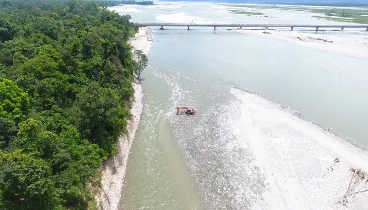
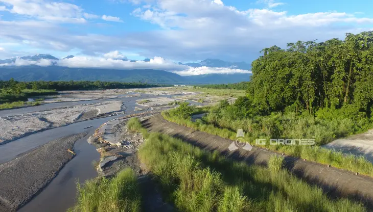
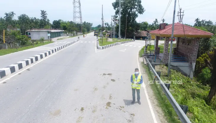
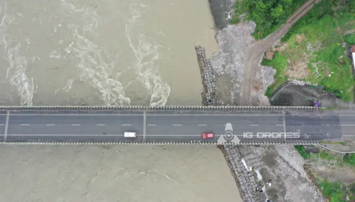
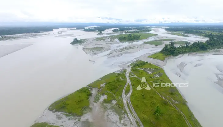
By leveraging breakthrough Drone technology, IG DRONES create an adaptive and scalable end-to-end solution. Our Aerial Survey, Mapping & Inspection Services have assisted the government and business sectors of the country in maintaining assets to their full capacity. We offer Drone based Powerline Monitoring, Industrial Inspection, Bridge Inspection, Solar Plant Inspection, Pipeline Inspection, Railway Services(Survey, Mapping & Inspection), Smart City Survey, Road Inspection, Mine Survey, Agricultural Survey, Forest & Wildlife Survey, Disaster Assessment, Wind Turbine Blades Inspection, Port Survey, Buildings and Skyscrapers Inspection, and Monuments Inspection, among other things in North-East India.
IG Drones aims to provide Aerial Drone Surveying, Mapping & Inspection services throughout Dibrugarh (Assam) & all of North-East India.Our expertise in land surveying, aerial surveying for land management and development, land slope monitoring, stockpile volumetric measurements, smart city design, greenfield project mapping, and other fields is unrivalled. IG Drones places a premium on quality and, as a result, consistently produces highly accurate topographic maps with centimetre-level accuracy at all times. Drone Data Processing is the current wave in the Geospatial realm, with drone applications spanning a wide range of sectors.Our clients get the deliverables faster thanks to high-end surveying drones and a team of expert licenced pilots. We continue to achieve up to 99 percent accuracy in Volumetric Measurements, Crop yield estimates, Damage Detection, and other areas using Artificial Intelligence and Machine Learning.This encourages quicker decision-making and definitely helps the clients in producing better outputs from Drone Survey, Mapping & Inspection in the hard to reach areas of North-East India


Talk to our team if you have any questions about drone surveying for your industry.
Contact Us for Drone Services in Assam Contact UsIG Drones provide specialist drone services at height and difficult to access areas across India. Technical end-to-end solution to help you ease your operation. Capture the smallest of details with ease. Raise your operational standards & Imagine more with us. Imagine Inspire Innovate.
Copyright © 2025. All Rights Reserved By IG Drones.
